Context
Civic Street is located at an intersection of major urban areas of Glasgow – Cowcaddens, Woodside, Speirs Locks, Sighthill and Dundashill. While the site is strategically located, it has long suffered due to the barriers of surrounding transport infrastructure – the M8 (south), canal (east) and the 4 lanes of Garscube road (west).
The following is analysis of the existing urban context combined with previous consultation and development projects: Connecting Woodside, Your City Centre, Glasgow North Strategic Development Framework, Speirs Locks Growing the People report, Firhill & Hamiltonhill Charrette. This formed the contextual research and basis for the Civic Street project.


Car culture
Since the construction of motorways transected the city, the development of Glasgow has been largely dependent on use of cars for transport. Motorways generate sprawling geographical barriers beyond their lanes – creating unwelcoming footpaths, vacant sites and separating communities.
Shown in red (on the map below) is the area of warehouses, large venues, and businesses, all with large parking lots that are concentrated around the motorway.
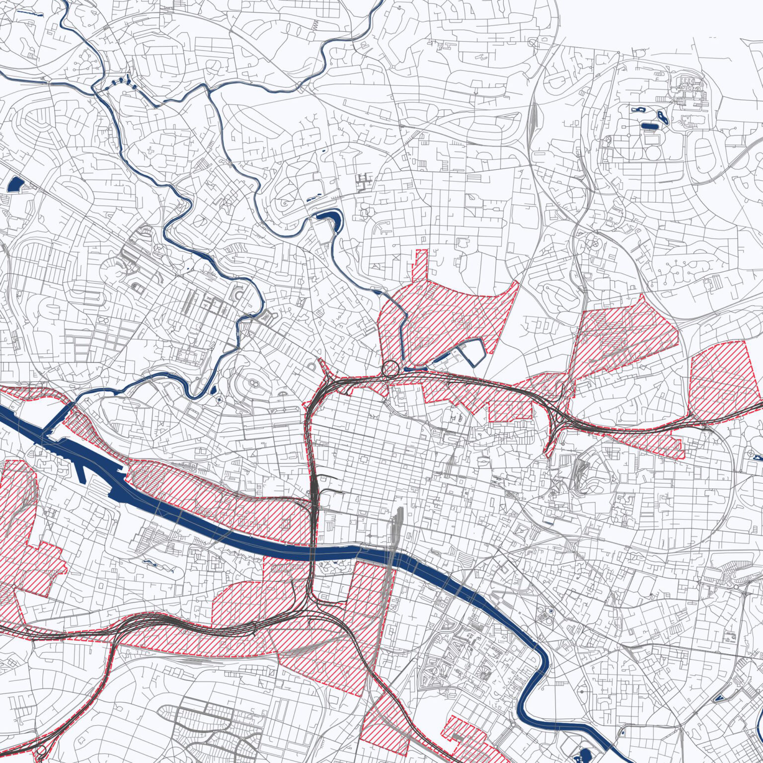
Map: Civic Street (circle) belong to one of the areas of the city overwhelmingly dominated by car culture (red): busy motorways, large industrial site with large delivery and transport vehicles, and parking lots. Map doesn't include suburban neighborhoods
Policy and Strategic Context
Goals of carbon neutrality are part of wider Glasgow City Council plans for urban regeneration, in which Civic Street occupies a strategically important position. Civic Street sits on the junction of cycling routes connecting several urban centres of Glasgow Development plans, as well as providing an east-west connection between cycling infrastructure projects: Connecting Woodside and Sighthill TRA.
The Civic Street Project aligns with principles of the Glasgow North Strategic Development frameworks in the following ways:
Principle 2 – The SDF (Strategic Development Frameworks) encourages the preparation of locally-led, EDA (Economic Development Areas) improvement plans to create more attractive and sustainable environments. Businesses could be supported to prepare plans that promote opportunities and set out landscape and active travel proposals. Such plans could help attract future investment and encourage appropriate supporting uses, contributing to the function and future viability of the EDA.
Principle12 – Speirs Locks Cultural Quarter – The SDF supports expansion of the performing and visual arts sectors at this location to help create a vibrant destination within walking distance of the city centre.
Principle 42 – The City Council will work with landowners and communities to strengthen the area’s green corridors:
Existing routes – enhance their value for nature and people through appropriate planting and landscaping; Improved southern corridor – increase the biodiversity and amenity of the route adjacent to the motorway; New green belt corridor – a new route creating improved habitats and accessibility along the green belt edge; Better connect up the green network through the creation of new pedestrian and cycle routes, including through the large scale development areas.
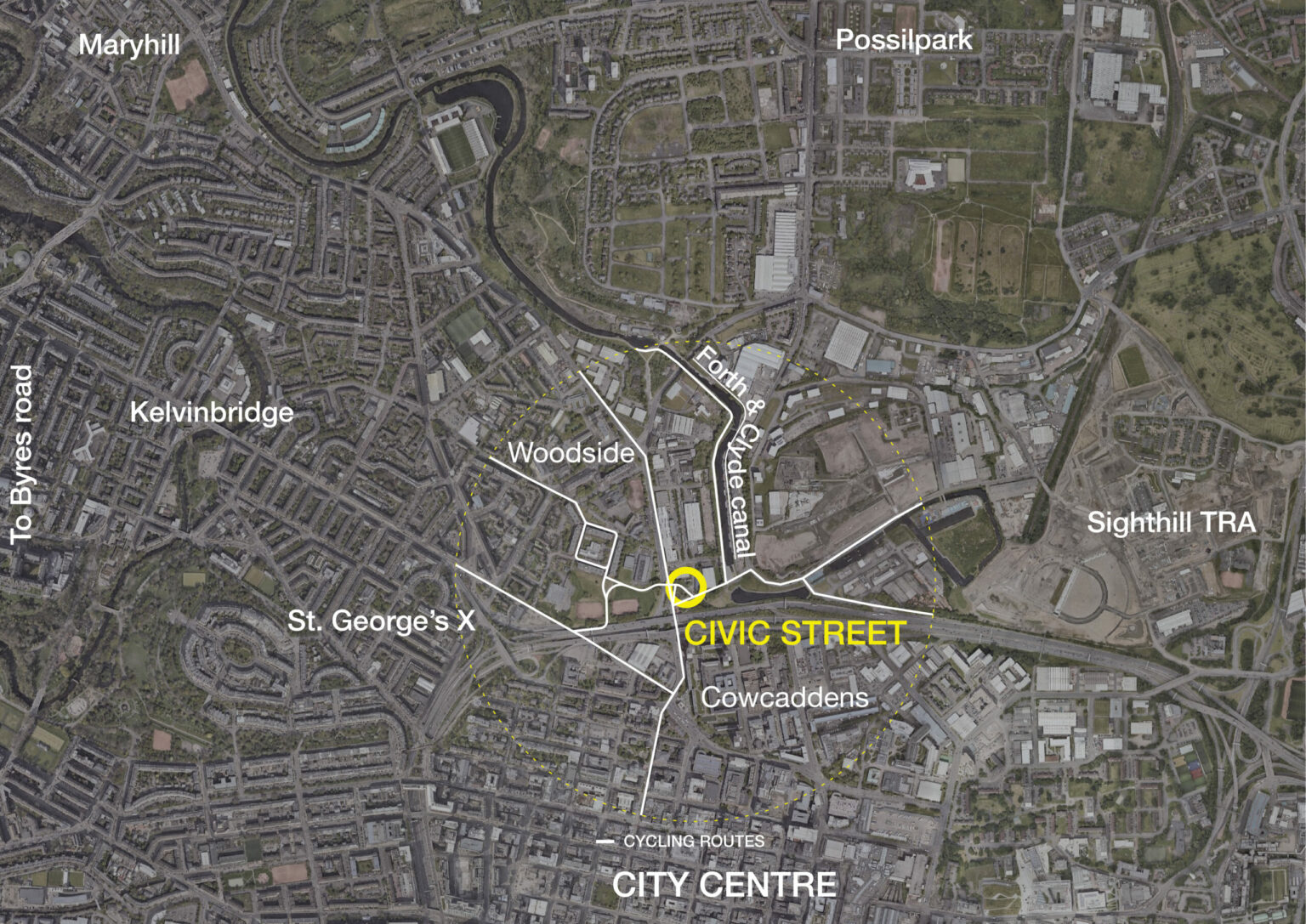
Civic Street in Glasgow North, at the intersection of cycling routes
Strategic projects in the area
North Glasgow is the location of numerous development and regeneration projects, with Civic Street (circle on map) positioned between.
The first completed projects in the area were limited instances of buildings across Speirs Locks being transformed for cultural production. This has been followed by infrastructural projects such as Phoenix Flowers underpass, Canal path, and the recently finished Garscube Rd Cycleway.
Ongoing projects include major developments like Sighthill TRA and Port Dundas; as well improvements to existing environments such as Woodside Making places, Connecting Woodside, Civic Street project, Canal Landscape link, and Canal Regeneration Project.
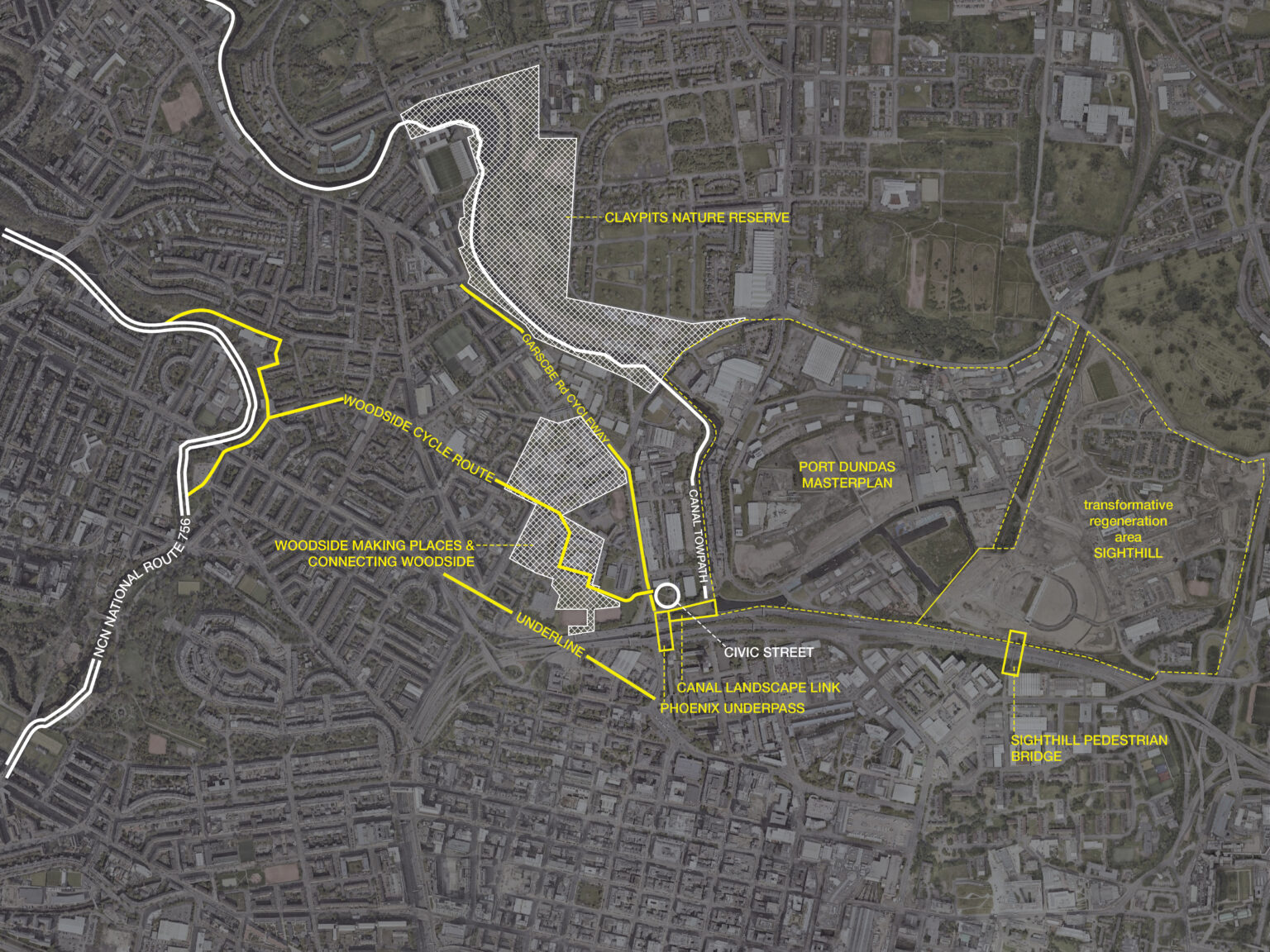
Position of Civic St between key active travel and urban regeneration projects


Green and Blue infrastructure
Open spaces in the area of Speirs Locks and leading up north predominantly consist of vacant and derelict land (red), compared to landscaped green areas (green); in Glasgow, around 60% of the population lives within 500m of such brownfields. Approaches to brownfields in the area fall into three categories: sites for immediate construction activity; sites used as speculative financial assets; and brownfields into greenfield sites of native biodiversity, such as at the Claypits through the Canal Regeneration project.
Civic Street falls into the last category, as its vacant and derelict sites provide an opportunity for creating a green corridor along the M8 focused on high-quality environment for active travel and enriched biodiversity.

